


Read this article in French German Italian Portuguese Spanish
Leica’s compact laser scanning system targets smaller contractors

24 July 2025
Leica Geosystems, part of Sweden-based industrial technology firm Hexagon, has released a bundled 3D scanning solution aimed at making laser-based reality capture more accessible to construction and design firms working on smaller-scale projects.
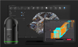 The Leica Geosystems BLK360 SE Essentials pacakage, including the BLK360 SE scanner, Cyclone FIELD 360 mobile app and PinPoint modelling software. Image: Leica Geosystems
Called the BLK360 SE Essentials, the offering combines a compact imaging scanner with field software and a simplified modelling interface.
Leica says the aim is to reduce the cost and complexity that have historically limited the use of 3D laser scanning on smaller or fast-moving jobsites.
The package includes the Leica BLK360 SE scanner, Cyclone FIELD 360 mobile app, and PinPoint modelling software. Together, the system allows users to capture a 360-degree laser scan in under one minute, accurate to 40mm from 10m. The scanner also uses a four-camera system to generate high-resolution (104-megapixel) HDR imagery for visual context.
Leica said the offering is targeted at professionals such as interior fit-out contractors who need to create precise templates of existing spaces to avoid measurement errors and material waste.
The FIELD 360 app guides users through scanning steps, helps align point clouds in real-time, and allows for quick in-field measurements. Back in the office, PinPoint enables users to convert point cloud data into 2D and 3D architectural models using drag-and-drop tools that align automatically with scanned geometry. The output is compatible with most CAD and BIM software.
The BLK360 SE is a lighter-weight alternative to Leica’s higher-end BLK360 model, aimed at projects that don’t require automated workflows or extended range scanning. The company said the new system could support a broader range of contractors and designers looking to integrate laser scanning into their workflows without major hardware investment.

STAY CONNECTED


Receive the information you need when you need it through our world-leading magazines, newsletters and daily briefings.


CONNECT WITH THE TEAM