


Discover the new Capture Reality solutions by Topcon
10 April 2025
SPONSORED CONTENT
Introducing the CR-H1 & CR-P1 Capture Reality solutions by Topcon
Topcon Positioning Systems is redefining capture reality technology with the launch of the CR-H1 and CR-P1.
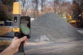
CR-H1 is a compact, handheld solution designed for seamless 3D data collection. Harnessing the power of PIX4Dcatch on iPhone devices with integrated LiDAR, the CR-H1 enables professionals across multiple industries to generate high-precision, full-color 3D point clouds with ease.
The CR-H1 meets the growing demand for intuitive and highly accurate data collection in the field. The specialized handle, designed and manufactured by Topcon, ensures ease of use, allowing users to capture data with one hand – eliminating the need for a tripod.
 CR-H1
CR-H1
To further improve data accuracy, the CR-H1 is also compatible with the Topnet Live subscription service by Topcon. This real-time GNSS correction service enhances the quality of georeferenced images and point clouds, ensuring superior results for every scan.
 CR-P1
CR-P1
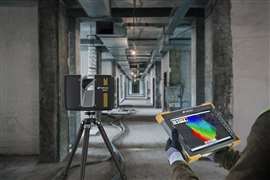
Topcon has also upgraded its Collage Site software solution providing new workflow capabilities that are designed to allow for the real-time acquisition and processing of data more accurately. The Collage Site solution allows a single operator to scan, process, and view complete georeferenced point clouds in real time while still in the field. This works for a number of hardware systems, including the new CR-P1 multi-functional 3D laser scanner by Topcon, providing real-time, georeferenced point cloud generation on-site and equipping the user with actionable data.
The new CR-P1 scanner, which can be used in combination with Collage Site, is the first product from the strategic agreement between Topcon and FARO Technologies to develop and distribute innovative solutions in the laser scanning market.
Key applications across industries
The CR-H1 and CR-P1 are versatile tools that serve a wide range of industries, including:
- Construction verification & earthworks: Quickly and accurately verify construction progress, ensuring projects stay on track and within specifications.
- Utilities & subsurface mapping: Efficiently capture georeferenced data for underground utility mapping and infrastructure planning.
- Civil engineering & site verification: Generate precise site models for analysis, planning, and execution.
- Land surveying & forensics: Enhance field workflows with fast, reliable data capture for detailed site documentation.
- 3D data capture of built & natural environments: Scan urban areas, historic sites, and landscapes to create rich, immersive 3D models.
STAY CONNECTED


Receive the information you need when you need it through our world-leading magazines, newsletters and daily briefings.


CONNECT WITH THE TEAM