


Read this article in 中文 Français Deutsch Italiano Português Español
What is the future of surveying?

14 March 2024
From state-of-the-art laser scanning and drone-based mapping to advanced geospatial data analytics, Catrin Jones looks at surveying’s development.
The integration of cutting-edge surveying technologies is transforming the construction industry by reshaping traditional methodologies and enhancing project efficiency.
In recent years, surveying technologies have found new sectors and expanded uses as surveyors have adopted a broader portfolio of technologies to benefit their projects.
Craig Hill, vice president of marketing and services at Leica Geosystems has seen a change in available technology. In addition to GPS/GNSS sensors and total stations becoming standard, Hill says that surveyors are also routinely integrating 3D laser scanning and deformation monitoring technology to grow their businesses.
“Increasingly, surveyors are seeing that their client base can be further expanded by embracing ground penetrating radar [GPR] to detect and map underground utilities to make construction safer and help make cities smarter.
“Furthermore, surveyors see mobile mapping as a way to grow their business and win new clients, especially as new intuitive mobile mapping systems simplify workflows and integrate artificial intelligence (AI) for faster and more efficient data processing.”
 Casey Cyrus, director of product management for site positioning systems at Trimble Civil Construction (Photo: Trimble)
Increasing adoption of surveying technologies
At Topcon Positioning, Leighton Davies, regional director of UK and Ireland at Topcon Europe Positioning believes that the adoption of surveying technology has been consistently increasing.
Davies says, “Although there hasn’t been a significant increase in the past couple of years, I think this trend will continue for the next five to ten years. This is because surveying technology is being used more frequently in non-traditional areas of survey.”
The reasoning behind this could point to the fact that the technology currently available on the market is simpler to use.
Casey Cyrus, director of product management for site positioning systems at Trimble Civil Construction, adds that he is seeing more people on construction sites looking for ways to report on or capture real-world conditions without having to bring in a licensed surveyor or use the construction surveyor that is all too often moving from project to project.
“Today,” says Cyrus, “The systems are simpler, and the use of survey technology is not just for the surveyor. One example is machine control systems, where the machines and machine operators are now delivering survey data back to the office, or even using it in the field to report on daily project progress.”
Some may argue that machine control is reducing the need for surveyors, but Cyrus believes that instead, we are empowering numerous functional roles by helping them utilise survey data, which benefits everyone.
Pushing forward
Advancements in technology are happening all the time – at an alarming rate – but how does surveying technology compare?
Leica Geosystems’ Hill says that his company’s surveying technologies incorporate advancements to create single compact sensors that extend far beyond their initial scope.
“For example, take the GPS/GNSS antenna. At first, surveyors collected data and processed it later. With the advent of radio links, surveying instruments could communicate in real-time, allowing for on-the-fly data exchange and processing directly in the field.
“This real-time communication enhanced the efficiency and capabilities of surveying operations, enabling applications like kinematic positioning, stake-out, and other dynamic surveying tasks.
“Mobile internet increased productivity further; now a single sensor could collect and process data from a network of static reference stations to provide real-time centimetre positioning for a seemingly endless number of applications that have gone far beyond surveying to machine control and autonomous vehicles.”
As Hill highlights, our mobile phones have the potential to change the way we work and make surveying more accessible.
Leica Geosystems recently launched the BLK2GO Pulse handheld first-person laser scanner to increase the accessibility of surveying and appeal to new audiences.
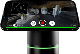 BLK2GO Pulse (Photo: Leica Geosystems)
Gianni-Philipp Patri, BLK product manager at Leica Geosystems, says that the BLK2GO Pulse first-person laser scanner allows “the user to capture easily and intuitively what they want using a smartphone. This makes laser scanning more accessible to those who are not familiar with the technology, allowing them to quickly get in touch with [Leica’s] new techniques.”
Patri highlights that the new scanner works in similar ways to that of smartphones. “When you want to take a video or capture a picture, it’s easy to do so. You capture the content that is most interesting to you. This is the similar thought process behind Leica’s first-person scanner.”
Patri adds, “It is a completely new user experience. One about how you perceive reality and how you capture reality, and also how to make use of the data.”
Changing how we work
Topcon’s Davies also sees this as the future of surveying. He describes it as “the democratisation of technology”.
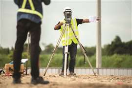
Davies says that 20 years ago GPS receivers were used exclusively by highly skilled individuals on construction sites and for land surveying operations. Previously, such technology was exclusive, very expensive and you were required to be a skilled operator to use it – but times are changing.
Survey technologies such as GNSS, optical data capture and layout are becoming as easy as using GNSS navigation systems in a vehicle or on a mobile phone, agrees Trimble’s Cyrus.
“As navigation systems are being widely adopted, users are becoming more acquainted with surveyor or navigator terms and processes. Also, modern survey systems are automating the data collection process using the same computing power that is available in a common personal computer. As technology has become more widespread among the world’s population, it has made adopting survey systems easier.”
The field of surveying has made significant advancements in technology, allowing for the capture of more data than ever before.
Cyrus highlights that the surveyors of the past are now adopting survey technologies that allow for the collection of more than a single point. He says that full 3D scans from terrestrial-based scanners or via aerial- or ground-based drones capture more data in a single session than traditional surveyors would have ever captured in the same amount of time.
He adds, “This big data has distinct advantages, giving consumers of this data a realistic view of the site with little-to-no additional CAD work. This can also help avoid additional site visits since current site conditions have been captured.”
The evolution of surveying
The rapid evolution of technology makes it challenging to predict its future direction as trends come and go but for Topcon’s Davies, the future of surveying technology is smaller, faster, lighter, and even more accessible to a wider audience.
“I think it’ll be results in real-time,” he says. “I think now, with some things that we do, you can get results in almost real-time.
“But I think almost all very near to real-time results in the field rather than processing data and sending it to an expert for analysis, I think that will become fairly commonplace.”
 As we advance on the road to autonomy, Trimble’s Cyrus thinks that the industry will continue to pursue the operator-assist functionality (Photo: AdobeStock)
As we advance on the road to autonomy, Trimble’s Cyrus thinks that the industry will continue to pursue the operator-assist functionality.
“For example, the automation of point collection has led to a transition for the surveyor. Previously, surveyors recorded field logs and raw data that needed manipulation to obtain the outputs. However, now raw data and results are available in the field without any office processing time.
Working together
Artificial Intelligence (AI) is a trending topic, but while it’s still uncertain how big a role it will play in construction, Leica’s Hill says it’s impossible to avoid it when talking about emerging technologies.
“Today AI is integrated into the software used to process GPR and Mobile Mapping data, and machine learning has been used in self-learning total stations and GNSS sensors for almost a decade.”
Despite this, Hill stresses that while technology will help surveyors; it will not replace them.
“As the technology evolves, its applications expand as well opening up new opportunities for surveyors,” says Hill.
 Surveyors use geospatial solutions to map and monitor environmental conditions and capture and visualise the data that helps make sustainable decisions (Photo: AdobeStock)
Surveying technology will play a crucial role in supporting climate change mitigation, he adds. Surveyors use geospatial solutions to map and monitor environmental conditions and capture and visualise the data that helps make sustainable decisions.
In other areas, Hill says, surveyors’ work will change. “Surveyors excel as data managers due to their specialised skills in accurately collecting, processing, and organising spatial information and their expertise in ensuring the reliability and accuracy of the data they handle.”
This means that surveyors will have the opportunity to play a crucial role in smart cities. Hill says that surveyors will be needed to integrate and manage spatial data from various mapping sources, ensure the seamless operation of diverse systems, including aerial, ground, and subsurface mapping for utilities, and maintain coordination across datasets
|
STAY CONNECTED


Receive the information you need when you need it through our world-leading magazines, newsletters and daily briefings.


CONNECT WITH THE TEAM