


Read this article in 中文 Français Deutsch Italiano Português Español
Trimble’s latest Connect extension streamlines datasets from UAVs, 3D laser scanning

11 September 2024
US-based Trimble – a global software and hardware technology services company – unveiled its newest product, Trimble Reality Capture, a secure web-based extension to Trimble Connect that holds and makes accessible massive reality capture datasets.
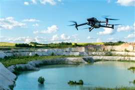 An uncrewed aerial vehicle (UAV) or drone flies over a quarry site. (Image: Adobe Stock)
Trimble said the Reality Capture programme is built to drive deeper collaboration among owners, contractors, surveyors and more, using secure and intuitive web-based solutions for point clouds and 360-degree imagery.
This new service serves as a secure platform to access reality capture data or imagery, including large datasets captured via mobile mapping by terrestrial laser scanners (including Trimble MX series and Trimble X9) as well as data from third-party hardware, Trimble said.
“Leveraging the extensibility of Trimble Connect that integrates data across Trimble connected software solutions, including Trimble ProjectSight construction management software, SketchUp 3D modelling tool and Tekla structural BIM software… this new service makes reality capture data accessible to various users,” explained Trimble.
The imaging tech uses 3D laser scanning, mobile mapping and uncrewed aerial vehicle (UAV) systems (or drones) to create the datasets, which can be easily accessed on Reality Capture. It serves as a support and extention to Trimble Connect, the firm’s cloud-based common data environment and collaboration platform.
“Professionals across building construction, surveying, transportation infrastructure, utilities, energy, mining and more can now collaborate on complex reality capture projects faster and easier, while maintaining data integrity by retaining original accuracy,” said the company.
The Colorado-based technology company added it integrated Microsoft Azure Data Lake Storage and Azure Synapse Analytics “to reduce the time ingesting, storing and processing massive datasets.”
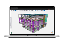 Trimble Connect and Trimble Reality Capture data and software modelling a structure. (Image: Trimble)
STAY CONNECTED


Receive the information you need when you need it through our world-leading magazines, newsletters and daily briefings.


CONNECT WITH THE TEAM