Read this article in 中文 Français Deutsch Italiano Português Español
Solar storms can hamper GPS-based construction surveys. What’s the solution?
02 July 2024
 Generated with Adobe Firefly
Anyone who was lucky enough to witness a spectacular display of the aurora borealis earlier this year will know that solar activity is on the rise.
Solar activity runs in cycles of 11 years and currently, we are approaching the peak of Solar Cycle 25. That means more sunspots, areas of intense magnetic activity that produces solar flares and coronal mass ejections (large expulsions of plasma and magnetic field from the sun). Hence many parts of the world unaccustomed to the northern lights suddenly being treated to colourful demonstrations of the phenomenon.
What does any of this have to do with construction? Unfortunately, stormy solar weather can also play havoc with surveying equipment that uses GNSS (Global Navigation Satellite Systems) signals.
“It tends to corrupt the GPS performance, including RTK (real-time kinematic positioning) for construction and surveying applications,” says Stuart Riley, vice president technology – GNSS at Trimble, the US-based technology company.
When plasma from the sun hits the ionosphere it generally follows magnetic field lines at the North and South Poles, says Riley.
Normally, solar activity tends to only really affect the furthest reaches of the north. But when it is strong, as it is currently, the problems can spread down into North America, the UK and Europe.
As more plasma is released from the sun, it hits the Earth’s ionosphere and can cause delays in GNSS signals as well as rapid attenuation.
The most recent major storm, in May, caused by particles emitted from a huge sunspot, was the most intense since 2003. “We saw a significant impact in northern Canada and through to more northern latitudes, but also across the US and even in the Bay area, which is extremely rare,” says Riley.
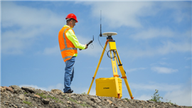
 A Trimble R750 modular GNSS receiver. (Image: Trimble)
“We definitely saw some issues in Scandinavia and the Nordic countries and we saw activity in Europe but it was not as bad there, even though there were some dramatic auroras.
“Last time we got lucky because it started at the close of a day on a Friday in the UK and the bulk of the activity was over by Monday. Had it been during working hours in the middle of a week then it would have been a lot more disruptive to operations.”
The biggest challenge is a degradation in signal that affects the ability to detect the position of equipment, says Riley. “You can have tracking problems where the signal gets attenuated to the point where you may not be able to track it for brief periods of time. This didn’t happen much in the recent storms,” he explains.
“The other effect is that measuring the distance to the satellite can get corrupted. For RTK, you have the base and you have the rover and we make a lot of assumptions about the measurements being correlated. When you get these high ionospheric activities you start to see some decorrelation of the error sources of the base and the rover.”
From a construction worker or surveyor’s point of view, that means that height measurements or horizontal position can start to shift, potentially making measurements less accurate.
“It can be extreme – all the way through to not being able to do RTK anymore, albeit only for brief periods,” says Riley.
What’s the solution?
This isn’t the first solar cycle to have happened in the age of RTK, says Riley. RTK technology has been under development since the 1990s and algorithms and the hardware have gradually improved over time, meaning that new systems perform better than the older ones.
That doesn’t mean that new systems are immune, however. “Different manufacturers are going to react to these problems in different ways. But generally, a potential degradation in position is a productivity issue for construction workers,” says Riley.
And as a result, work has already been underway for some time to keep disruption to a minimum as we reach the solar maximum (the greatest period of solar activity in the cycle), expected to fall between late 2024 and early 2026, according to the US’s National Oceanic and Atmospheric Administration’s (NOAA) Space Weather Prediction Center (SWPC).
“Around three years ago, we knew the cycle was going to heat up. It’s very predictable,” says Riley.
“We know that two to three years before the peak, historically we have started to detect problems and they have continued for two to three years after that. So for up to about six years in an 11-year cycle we tend to have minor problems. Generally, it is in more extreme locations – very northern locations, where we’d start to see if first. Then there are some unique problems in equatorial regions such as Brazil that are early indicators of activity.”
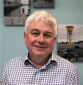
 Stuart Riley
Riley and his colleagues at Trimble started collecting a wealth of data around three years ago, deploying equipment in various places around the world as well as using data from the company’s RTX network that has stations around the world. They also used sophisticated radio frequency (RF) recording to record storms and take them back to the lab to study them and work out ways to protect signals.
“If we can record a storm, we can bring that back to the lab and replay it over and over again and fine tune the algorithms at a really low level. That is something we didn’t have available last time.”
The result of all this data collection and algorithm twiddling has been a new product called ‘IonoGuard’, which was released late last year and rolled out as a free upgrade to anyone using Trimble’s support services. “It monitors measurement on a satellite-by-satellite basis and tries to estimate three different ionospheric-related parameters,” explains Riley.
“From there, we can adjust the position engine based on what we determine from these parameters on a per-satellite basis. You will often find that solar storms don’t necessarily light up the whole sky but there will be patches of sky that are affected. There will be some satellites that are extremely affected, some mild and some not at all. By estimating what is happening on a per-satellite basis, we can more optimally configure the position engine and then you derive a better estimate of the position.”
When solar activity becomes particularly strong, the system that Trimble has designed kicks in and compensates for areas that have been badly affected to keep measurements more accurate.
“What we found is that during benign periods of time, these detectors are not triggering but during solar storms, they start to trigger and we start to adjust the engine and we start to see quite a substantial improvement when that happens,” says Riley.
IonoGuard worked “really well” during the latest storm he says, and to prove it he published data from a location in Canada where previously there have been significant issues with RTK.
While professing not the be an expert on the subject, Riley expects further storms to occur. “We can certainly expect more storms. Could they be of the magnitude we saw recently? Possibly. It could be higher, it could be lower – it is not a predictable thing. Potentially, next time it may affect operations in a different geographic area. It may not be North America – it could be Europe or somewhere else.
Advice for future storms
When it comes to preparing for the effects of future solar storms, Riley’s first advice is for users of Trimble’s technology is to make sure they are using the latest firmware and that IonoGuard is enabled.
More generally, he adds, “From an RTK perspective, if historically you have been pushing the baseline length, then reconsider that. If you were getting away with a base and rover separation that’s really long in benign conditions then consider whether it would be practical to reduce that. It will depend on the operation. Some construction sites are only a few hundred metres up to kilometres. Some operations may be pushing into the tens of kilometres. So you review things like that and the technology you are using to ensure you have all the features you need enabled.”
STAY CONNECTED


Receive the information you need when you need it through our world-leading magazines, newsletters and daily briefings.
CONNECT WITH THE TEAM


